Monte Matteo
| Monte Matteo | |
|---|---|
| Paraguay | |
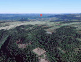
View from the East
The Asunción Rift Valley in background |
|
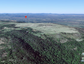
View from the West
The Asunción Rift Valley in background |
|
| Quick Facts | |
| Elevation | 435 meters (1427 feet) |
| Noteable |
|
| Coordinates | 25°35'34.8"S 57°05'24.2"W / 63.0695°N X151.0074°WCoordinates: 25°35'34.8"S 57°05'24.2"W / 63.0695°N x151.0074°W |
| Geography | |
Mte. Matteo
|
|
| Location | 15 kilometers from Paraguarí |
| Accessibility | |
| Easiest route | Ruta Paraguari-Piribebuy |
| Restricted | Private land |

Monte Matteo, Republic of Paraguay (also known as Mont Matteo) is a private 60 hectare (148 acre) park situated on an elevated land mass that is 435 meters (1427 feet) above sea level.
Located 70 kilometers from the capital of Asunción, the park is the home of The Monte Matteo Visual Arts Archive, an international art heritage program. It is also the main office of the Mountain Data Bank, a secure data archiving facility.
The park is a private conservation site that overlooks 200 kilometers of Paraguay's most important geological feature, the Asunción Rift Valley. [3D Interactive Map]
At the summit is the highest observation structure in Paraguay, El Monumento. It is a twenty meter tower and the headquarters of an international club of the same name that supports the private conservation of the site.
Many of Paraguay's most well-know geological formations, including two natural monuments, can be been seen from the summit.
Contents
Vista[edit]
The summit of Monte Matteo permits a 74 kilometer view towards the horizon and a total viewing diameter of approximately 200 kilometers from Lago Ypacaraí to the Cordillera del Ybytyruzú.
The park overlooks the three sections of the Asunción Rift Valley: the western segment, running 90 kilometers in a Northwest to Southeast direction between Benjamin Aceval and Paraguarí; the central section running 70 kilometers from Paraguarí to Villarrica in an East to West direction; and the eastern section running 40 kilometers from Villarrica to the Ybytyruzú Mountains.
The most significant geological features and historical sites of the Asunción Rift Valley can be seen from the park.
-
Geological Features Viewable from Mte. Matteo
- Cerro Porteño [Esp] [Official]
- Lago Ypacaraí [Esp] [Eng]
- Cordillera de los Altos [Esp]
- Cerro Acahay (Mountain), *Monumento Natural* [Wiki] [Official]
- Cerro Mbatoví
- Las Serranías de Paraguarí
- Cerro Santo Tomás (Mountain), *Monumento Natural* [link] [Official]
- Las Sierras de Ybycuí
- Sapucaí - La Colmena Zone
- Cerro Tres Kandú (Mountain) [Esp] [Eng]
- Cordillera del Ybytyruzú [Esp]
Educational Use[edit]
The site is used to host educational programs that focus on the human history and the geological history of the Asunción Rift Valley.
Monte Matteo contains surface level examples and geological characteristics representing major stages of earth's history and geological processes.
The park and the surrounding Asunción Rift Valley contain an abundance of visible geological features that formed during the break-up of the Gondwana supercontinent approximately 130 million years ago. This time period is associated with the final stages of the Gondwana break-up that separated the Gondwana continent into the continents of South America and Africa.
Nearby mountains[edit]
Many of Paraguay's mountains are locally referred to as hills (cerros). However, Cerro Tres Kandú, Cerro Hú, Cerro Acahay, and Cerro Santo Tomás. are mountains. The international altitude standard of a mountain is 304 meters (1000 feet).
Monte Matteo is located 4 kilometers from Cerro Hú, 31 kilometers from Cerro Acahay, and 2 kilometers from Cerro Santo Tomás..
History[edit]
From the early 1800's until 2016 the area that now comprises Monte Matteo was principally used for agriculture and cattle grazing.
In 2017 parts of the park were designated for operations related to The Monte Matteo Visual Arts Archive and other parts were designated as scenic overlook areas for tourism.
The name of the park is attributed to the immigrant land owner, Matteo, that unified ownership of the land at the summit.
Location[edit]
The park is situated 435 meters above sea level in Paraguay's Municipality of Paraguarí, 15 kilometers from the city of Paraguari, 4 kilometers North of Cerro Porteno, 2 kilometers North East of Cerro Santo Tomás, and 5 kilometers South East of Cerro Mbotovi. GPS Position: 25°35'34.8"S, 57°05'24.2"W